Tie-back Tool
Overview
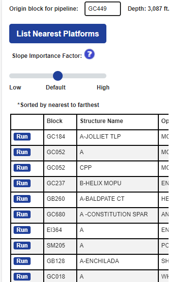
Tie-Back Tool takes an origin block in deep water and a destination platform within 60 miles of the block and estimates a pipeline route...
Input
Deepwater Block (Origin), Slope Importance (Directly affects the length and complexity of pipeline path), Destination Platform...
Output
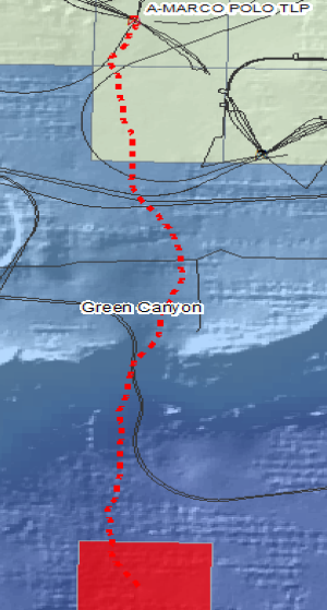
Zip file containing: Report (PDF reviewing selected origin block, destination platform’s production and oil, gas and water capacity, cross-section...
Method: Cost-Distance Calculation
Optimal path is calculated using an A* search algorithm where the Gulf of Mexico is treated as a network...
Overview
The Tie-Back Tool takes an origin block in deep water and a destination platform within 75 miles of the block and estimates a pipeline route. Pipeline route is based on slope, incremental distances from the chosen block to platform, and an importance of slope based on user input. The resulting analysis provides an in-depth review of the selected block, platform, and “optimal” pipeline route.
For a deeper dive into the workings of the pipeline routing in this tool, click here.
Input
The primary way to access data begins by entering a block number to see summary information on leases, fields, wells, completions, platforms, planned sites, and pipelines on that block.
- Deepwater Block/Coordinates (Origin)
- Slope Importance (Directly affects the length and complexity of pipeline path)
- Maximum Slope
- Destination Platform OR Pipeline Tie-in OR custom coordinates
Output
Zip file containing:
- Report (PDF reviewing selected origin block, destination platform’s production and oil, gas and water capacity, cross-section graph of pipeline, statistical comparison against existing pipelines and image of route)
- Text file(CSV) of all points of route (XY coordinates and elevation)
- Shapefile (polyline of route in NAD1927 UTM Zone 15N)
Method: Cost-Distance Calculation
Optimal path is calculated using an A* search algorithm where the Gulf of Mexico is treated as a network. Movement through the 100m cell sized grid is both perpendicular and diagonal with diagonal distances at 1.414(the square root of 2) and perpendicular distances at 1. A weight is assigned to every connecting cell as a function of distance and slope. A plethora of paths are simulated and each path is given a score representing the sum of its cell weights. The best path chosen is the considered to be the one with the lowest score. Due to the discrete nature of the grid, the path is smoothed using a 5-point moving average.