Keywords
Theme:
seismic survey, 2-D, Earth Science Associates, GOMsmart, GOM3, GOM-Cubed, seismic, add-on
Place:
Gulf of Mexico, GOM, USA
Stratum:
Offshore
Temporal:
Current
Description
Abstract
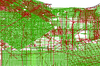
2-D seismic navigation lines released by the BSEE.
Purpose
Displays navigation lines for 2-D seismic surveys in the Gulf of Mexico. These lines go with preview images and SEG-Y files in the Seismic Add-on to GOM3.
_________________
Status of the data
Complete
Data update frequency: As needed
Data update frequency: As needed
Time period for which the data is relevant
Description:
publication date
Publication Information
Who created the data:
US Bureau of Ocean Energy Management, Bureau of Safety and Environmental Enforcement, Earth Science Associates
Date and time:
20170609
Series name:
BSEE Website/Public Sources
_________________
Data storage and access information
File name:
fault
Type of data: vector digital data
http://www.boem.gov
Data processing environment:
Microsoft Windows 7; ESRI ArcCatalog 10.2.2
Type of data: vector digital data
Location of the data:
Accessing the data
Size of the data:
76.1 MB
Data transfer size: 76.1 MB
Data transfer size: 76.1 MB
Constraints on accessing and using the data
Access constraints:
Licensed GOM-Cubed Users
Use constraints:
License Terms under GOM-Cubed license agreement
Details about this document
Contents last updated: 20170609
at time 16015600
Who completed this document
DBA
Earth Science Associates
mailing and physical address:
(562) 428-3181 (voice)
(562) 428-3186 (fax)
contactesa@earthsci.com
Earth Science Associates
mailing and physical address:
4300 Long Beach Blvd., Ste. 310
Long Beach, CA 90807
USA
(562) 428-3181 (voice)
(562) 428-3186 (fax)
contactesa@earthsci.com
Hours of service:
9-6- Pacific Time (Monday-Friday)
Standards used to create this document
Standard name:
FGDC Content Standards for Digital Geospatial Metadata
Standard version: FGDC-STD-001-1998
Time convention used in this document: local time
Metadata profiles defining additonal information
ESRI Metadata Profile:
http://www.esri.com/metadata/esriprof80.html
Standard version: FGDC-STD-001-1998
Time convention used in this document: local time
Metadata profiles defining additonal information
Horizontal coordinate system
Geographic coordinate system name:
NAD_1927_UTM_Zone_15N
Details
Projected Coordinate System
Latitude Resolution:
0.0000000
Longitude Resolution:
0.0000000
Projected Coordinate Units:
Meters
Geodetic Model
Horizontal Datum Name:
North American Datum of 1927
Ellipsoid Name:
Clarke 1866
Semi-major Axis:
6378206.400000
Denominator of Flattening Ratio:
294.978698
Depth System Definition
Datum Name:
Mean sea level
Distance Units:
meters
Encoding Method:
Attribute values
_________________
Bounding coordinates
Horizontal
In projected or local coordinates
Left:
77489.2176998124
Right:
1790999.32057296
Top:
3363866.79450764
Bottom:
2646699.39770157
_________________
Lineage
FGDC lineage
Process step 1
Process description:
ESA purchased the original file from BSEE. The data were then cleaned and formatted. A shapefile was created.
Who did this process
DBA
Earth Science Associates
mailing and physical address:
(562) 428-3181 (voice)
(562) 428-3186 (fax)
contactesa@earthsci.com
Earth Science Associates
mailing and physical address:
4300 Long Beach Blvd., Ste. 310
Long Beach, CA 90807
USA
(562) 428-3181 (voice)
(562) 428-3186 (fax)
contactesa@earthsci.com
Hours of service:
9-6 Pacific Time (Monday-Friday)
_________________
Spatial data quality
Horizontal positional accuracy
BSEE data checked for obvious errors in entry. ESA calculated values checked for quality.
Vertical positional accuracy
BSEE data checked for obvious errors in entry. ESA calculated values checked for quality.
_________________
Spatial data description
Vector data information
ESRI description
fault
ESRI feature type:
Simple
Geometry type: Polyline
Topology: FALSE
Feature count: 13105
Spatial Index: TRUE
Linear referencing: FALSE
Geometry type: Polyline
Topology: FALSE
Feature count: 13105
Spatial Index: TRUE
Linear referencing: FALSE
SDTS description
line:
String, 13105
Feature class: SDTS feature type, feature count
Details for NavLines
Type of object:
Feature Class
Number of records:
13105
Description
Displays navigation lines for 2-D seismic surveys in the Gulf of Mexico. These lines go with preview images and SEG-Y files in the Seismic Add-on to GOM3.
Attributes
FID
Alias:
FID
Data type: FID
Width: 4
Precision: 0
Scale: 0
Definition: Internal feature number. Definition Source: ESRI
Data type: FID
Width: 4
Precision: 0
Scale: 0
Definition: Internal feature number. Definition Source: ESRI
Shape
Alias:
Shape
Data type: Geometry
Width: 0
Precision: 0
Scale: 0
Definition: Feature geometry. Definition Source: ESRI
Data type: Geometry
Width: 0
Precision: 0
Scale: 0
Definition: Feature geometry. Definition Source: ESRI
YEAR
Alias:
Acquisition Year
Data type: Short
Width: 0
Number of decimals: 0
Data type: Short
Width: 0
Number of decimals: 0
SURVEY
Alias:
Survey name
Data type: String
Width: 254
Data type: String
Width: 254
SEGP1
Alias:
Survey Name in SEGP1
Data type: String
Width: 254
Data type: String
Width: 254
LINE
Alias:
Line Name
Data type: String
Width: 254
Data type: String
Width: 254
OPERATOR
Alias:
Company Name
Data type: String
Width: 254
Data type: String
Width: 254
SURLINE
Alias:
Survey Line ID
Data type: String
Width: 254
Data type: String
Width: 254
LENGTH
Alias:
Length (in meters)
Data type: Long
Width: 0
Number of decimals: 0
Data type: Long
Width: 0
Number of decimals: 0
FIRSTSHOT
Alias:
First Shot Number
Data type: Long
Width: 0
Number of decimals: 0
Data type: Long
Width: 0
Number of decimals: 0
LASTSHOT
Alias:
Last Shot Number
Data type: Long
Width: 0
Number of decimals: 0
Data type: Long
Width: 0
Number of decimals: 0
SEGY
Alias:
SEG-Y file indicator (1=available)
Data type: Short
Width: 0
Number of decimals: 0
Data type: Short
Width: 0
Number of decimals: 0
SHOTS
Alias:
Shot direction (1=orientation to image)
Data type: Short
Width: 0
Number of decimals: 0
Data type: Short
Width: 0
Number of decimals: 0
SMPLINT
Alias:
Sample interval (in milliseconds)
Data type: Short
Width: 0
Number of decimals: 0
Data type: Short
Width: 0
Number of decimals: 0
VELOCITY
Alias:
Average velocity (in feet/second)
Data type: Long
Width: 0
Number of decimals: 0
Data type: Long
Width: 0
Number of decimals: 0
NUMSMPLE
Alias:
Samples per trace
Data type: Long
Width: 0
Number of decimals: 0
Data type: Long
Width: 0
Number of decimals: 0
SEISFLAG
Alias:
Displayable in 3-D scenes
Data type: String
Width: 20
Data type: String
Width: 20