Using GOMsmart
What is GOMsmart
GOMsmart gathers all the publically released data on oil and gas exploration and development in the Gulf of Mexico into an easy to navigate website...
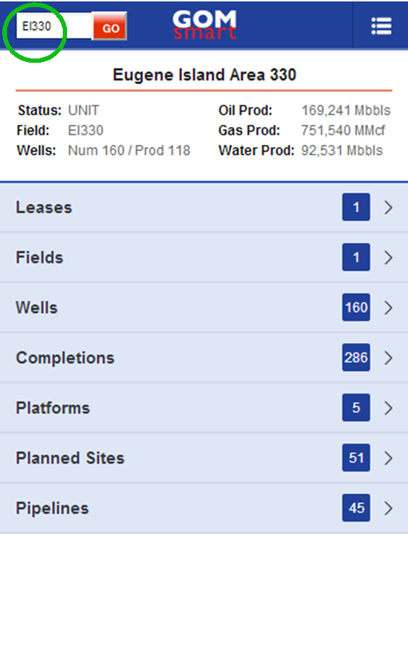
Getting Started
The primary way to access data begins by entering a block number to see summary information on leases, fields, wells, completions, platforms, planned sites, and pipelines on that block...
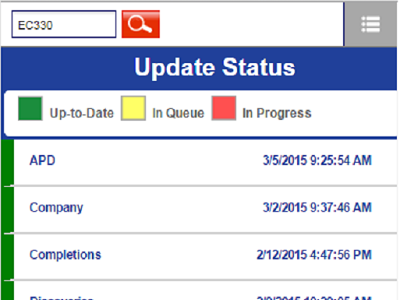
Data in GOMsmart
GOMsmart always provides the most up-to-date information as the data is updated every hour of every day. Some data and reports are accessed in real time directly from BOEM servers...
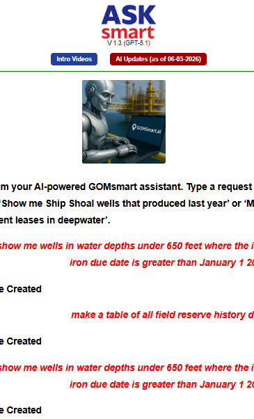
AskSmart
is an AI-powered assistant to help compile and analyze GOMsmart data by typing simple English questions or requests. It produces custom tables, charts and interactive maps...
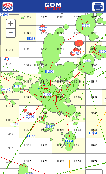
Smart Mapping
GOMsmart provides an interactive map of all leases, fields, wells, completions, plans and facilities...
What is GOMsmart
GOMsmart gathers all the publically released data on oil and gas exploration and development in the Gulf of Mexico into an easy to navigate website that can be viewed on any device.
- It provides detailed information on single features – for instance, a specific lease or well.
- You can generate charts and download data for use offline.
- You can define custom reports to find multiple features (e.g., all wells in water depth over 1,000’).
- Even more data is available in map view with layers that can be turned on and off.
Getting Started
The primary way to access data begins by entering a block number to see summary information on leases, fields, wells, completions, platforms, planned sites, and pipelines on that block.
- Enter an area-block in the upper left corner. If you know an ID of a particular feature like a field name or well API, you can enter that as well.
- You can now view all leases, fields, wells, completions, platforms, planned sites, and pipelines on that block. The number on the right indicates the number of records of each dataset.
- Selecting a feature will take you to the feature info page to access other functions and more detailed information.
Data in GOMsmart
GOMsmart always provides the most up-to-date information as the data is updated every hour of every day. Some data and reports are accessed in real time directly from BOEM servers.
GOMsmart is an exhaustive compilation of data for oil and gas development in the Gulf of Mexico. Both current and historical records are accessible. It is updated hourly: 24/7. so you can check the update status to see when new records were added to a dataset or check what datasets are currently being updated.
AskSmart
AskSmart is an AI-powered assistant to help compile and analyze GOMsmart data by typing simple English questions or requests. It produces custom tables, charts and interactive maps to meet your exact needs. AskSmart also generates text answers to questions or requests for specific analysis.
Type in a question or request. AskSmart may ask a clarifying question or two. It then accesses all GOMSmart tabular data, mapping data and hundreds of GOMsmart/BOEM/BSSE documents. It also has learned from access to scrubbed user support emails over the last 25 years.
Smart Mapping
GOMsmart provides an interactive map of all leases, fields, wells, completions, plans and facilities. Using AskSmart, data can be loaded, re-colored, labeled and filtered. Clicking on the map will retrieve a list of features in the area (a “Hotlink”) if you want more information. Maps can also be exported for viewing off-line or printing.