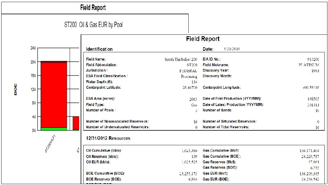
- BOEM Field classification
- BOEM Field status
- Field type
- Field Jurisdiction
- Field structure
- Field primary trap type
- Field secondary trap type
- Field discovery date
- Field discovery year
- Discovery date of last reservoir discovered in field
- Discovery year of last reservoir discovered in field
- Discovery well API number
- Energy Information Administration identification number
- Planning area
- Assessed Yes or No
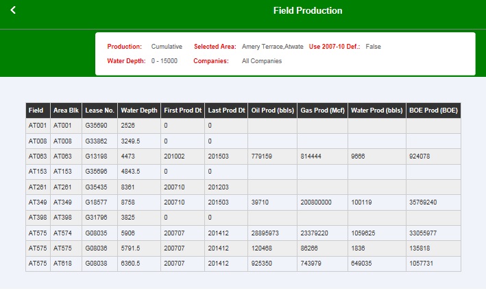
- Water depth (feet)
- Proved or Unproved
- Proved EUR Oil of last BOEM Atlas (bbl)
- Proved EUR Gas of last BOEM Atlas (Mcf)
- Proved EUR Gas of last BOEM Atlas (BOE)
- Proved EUR BOE of last BOEM Atlas (BOE)
- Cum Oil produced of last BOEM Atlas (bbl)
- Cum Gas produced of last BOEM Atlas (Mcf)
- Cum Gas produced of last BOEM Atlas (BOE)
- Cum BOE produced of last BOEM Atlas (BOE)
- Proved remaining oil reserves of last BOEM Atlas (bbl)
- Proved remaining gas reserves of last BOEM Atlas (Mcf)
- Proved remaining gas reserves of last BOEM Atlas (BOE)
- Proved remaining BOE reserves of last BOEM Atlas (BOE)
- Unproved recoverable oil of last BOEM Atlas (bbl)
- Unproved recoverable gas of last BOEM Atlas
- Unproved recoverable gas of last BOEM Atlas (BOE)
- Unproved recoverable BOE of last BOEM Atlas (BOE)
- Discovered oil (bbl) Proved EUR + Unproved
- Discovered gas (Mcf) Proved EUR + Unproved
- Discovered gas (BOE) Proved EUR + Unproved
- Discovered BOE (BOE) Proved EUR + Unproved
- Subsea depth (feet)
- Initial pressure (psi)
- Initial temperature (degrees F)
- Sand pressure gradient (psi per foot)
- Sand temperature gradient (degrees F per 100 feet)
- Initial solution gas-oil ratio (Mcf/bbl)
- Condensate Yield (stb/MMcf)
- Gas-oil ratio (Mcf/bbl)
- Gas specific gravity (decimal at 60 degrees F and 15.025 psia)
- Oil API gravity
- Oil in place (bbl)
- Gas in place (Mcf)
- Oil reservoirs’ recoverable oil (bbl)
- Oil reservoirs’ recoverable gas (Mcf)
- Produced GOR for oil reservoirs (Mcf/stb)
- Gas reservoirs’ recoverable oil (bbl)
- Gas reservoirs’ recoverable gas (Mcf)
- Produced GOR for gas reservoirs (Mcf/stb)
- Count of non-associated gas reservoirs
- Count of oil reservoirs
- Count of saturated oil reservoirs
- Count of total reservoirs
- Number of Sands (BOEM)
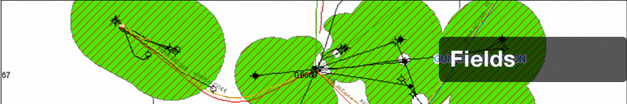
- Field Area (ESA)*
- Centerpoint Longitude*
- Centerpoint Latitude*
- First Production Date*
- Last Production Date*
- Number of Pools*
- Number of Sands (ESA)*
- EUR Oil of last Reserve History (bbl)
- EUR Gas of last Reserve History (Mcf)
- EUR Gas of last Reserve History (BOE)
- EUR BOE of last Reserve History (BOE)
- Cum Oil produced of last Reserve History (bbl)
- Cum Gas produced of last Reserve History (Mcf)
- Cum Gas produced of last Reserve History (BOE)
- Cum BOE produced of last Reserve History (BOE)
- Remaining oil reserves of last Reserve History (bbl)
- Remaining gas reserves of last Reserve History (Mcf)
- Remaining gas reserves of last Reserve History (BOE)
- Remaining BOE reserves of last Reserve History (BOE)
- Current Cum. oil prod (bbl)*
- Current Cum. gas prod (Mcf)*
- Current Cum. gas prod (BOE)*
- Current Cum. water prod (bbl)*
- Current Cum. BOE prod (BOE)*
- Oil Prod of Last Calendar Year (bbls)*
- Gas Prod of Last Calendar Year (Mcf)*
- Gas Prod of Last Calendar Year (BOE)*
- Water Prod of Last Calendar Year (bbls)*
- BOE Prod of Last Calendar Year (BOE)*
- Number of Producing Wells Last Calendar Year*
- Number of Producing Completions Last Calendar Year*
- Number of Platforms*
- Number of Wells*
- Number of Completion Intervals*
- Number of Completions*
- Number of Tests*
- Number of New Wells in Last Calendar Year*
- Number of New Completions in Last Calendar Year*
- Number of New Platforms in Last Calendar Year*
- Oil/Water Cut (bbl/bbl) Last Calendar Year*
- Gas/Water Cut (Mcf/bbl) Last Calendar Year*
- Oil Productivity (bopd/prod well) Last Calendar Year*
- Gas Productivity (Mcf per day/prod well) Last Calendar Year*
- ESA field classification*
- Field Nickname*
- Field Name
- Block Shape Flag*